Grand Canyon Traverse the Hard Way
August 22-25, 2021 Intended Itinerary
Day #1: fly to Las Vegas, drive to Grand Canyon, overnight at Kachina Lodge
Day #2: leave 3:30am and hike from South Rim to North Rim. Immediately turn around and hike through the night back to South Rim
Day #3: arrive South Rim by 3:30am, overnight at Kachina Lodge
Day #4: drive to Las Vegas, fly home
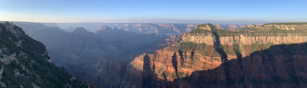
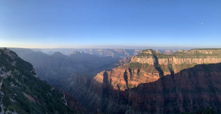
Hiking in the Grand Canyon
There are very few places in the world as magnificent to hike in as the Grand Canyon. Yet, ninety percent of the visitors there never venture below the trails on the rim. Why? There are three main reasons:
- There is no need to sweat. The best views of the Canyon in all its glory are available right there on the rim;
- As a bucket-list destination the Grand Canyon tends to attract and older crowd with most visitors being over age 50; and
- It is very hard to hike uphill at an altitude that few people are accustomed to.
The upshot is that relative solitude is assured for the handful of hikers who do venture below the rim. No permits are required for those who are not camping overnight. The only logistical limitation spur-of-the-moment visitors have to contend with is limited availability of rooms at the concessionaire hotels within the Park.
In the Grand Canyon, relative solitude is assured for the handful of hikers who venture below the rim.
Motivation
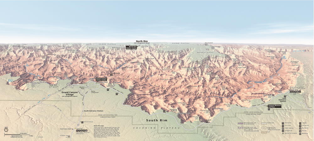
I have done the classic Rim-River-Rim hike five times since first coming to the Grand Canyon in 2004. Using the South Kaibab Trail for the rim-to-river leg and the Bright Angel Trail for the river-to-rim finishing leg, it is a classic 16.8-mile / 27 kilometer journey that is unquestionably the most popular extreme hike the park has to offer. Seven years ago, I got to experience the wonders of the North Rim and inner Canyon for the first time while doing a North Rim to South Rim traverse. That 24-mile / 39 kilometer journey was wonderfully satisfying. However, in the intervening years other objectives took precedence over a return to the Grand Canyon. Then the COVID pandemic happened and the world came to a screeching halt.
As COVID-related travel restrictions finally began to ease and vaccines became widely available in April of 2021, I started thinking about doing the ultimate Grand Canyon hike, the 48-mile / 77 kilometer South Rim-to-North Rim-to-South Rim extravaganza popularly known as the “R2R2R”. My only disappointment was that I could not do it right away– hotels on the South Rim were booked solid through late August. But, the delay had one big upside in that it allowed my daughter, Germaine, the time necessary to schedule herself into the trip.
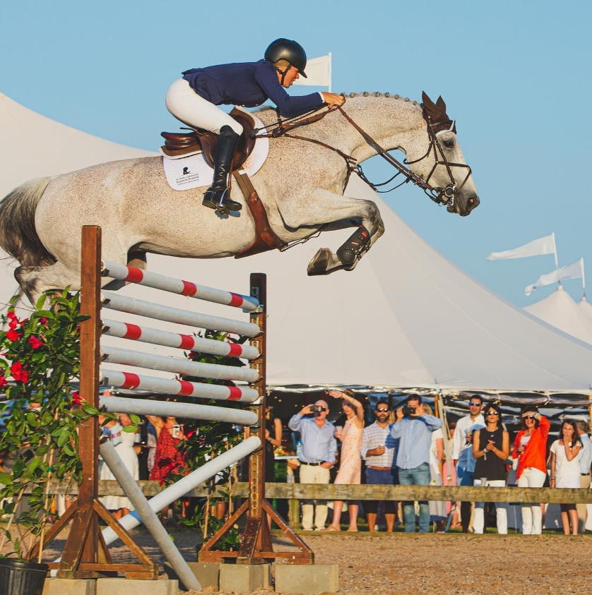
Germaine is a professional athlete. She makes her living training and riding horses. Based in the outdoor sports-obsessed town of Bend, Oregon she owns Some Day Farm and regularly competes in elite jumper events at horse shows all over the country. It is both terrifying and beautiful to watch her riding immensely powerful horses around courses filled with impossibly high jumps. Besides being a world-class rider, Germaine has impeccable long distance running credentials as well. She has done numerous marathons, a full Ironman Triathlon and a 50-mile ultra-marathon. Young and marvelously fit she was the perfect companion for the R2R2R. Pre-trip we were optimistic about being able to finish the hike in one continuous 24-hour push.
The R2R2R is a tough 48-mile extravaganza.
Red Flags Waving
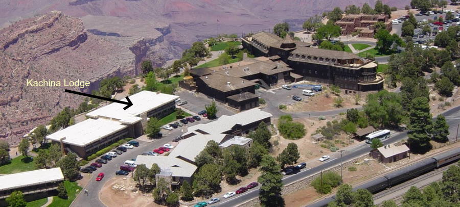
We flew into Las Vegas on Sunday, August 22, 2021, grabbed a rental car and set out on the 4½ hour drive to the Grand Canyon at about noon. The trip went flawlessly and by 5pm we were safely tucked away in our rooms at the Kachina Lodge. The Lodge is perfectly located right on the canyon’s rim and only a short walk away from the start of the Bright Angel Trail. All was good for a start in the wee hours of the morning except for one thing– the weather.
I had been keeping track of weather conditions at the National Park Service website and was alarmed about what it said on the eve of our departure:
DANGER: Excessive Heat Warning!
Mostly sunny today, with a high near 90 °F (32 °C) on the South Rim and reaching 120 °F (49°C) inside the canyon. Best to avoid outdoor activities.
An accompanying video by the National Park Service Search and Rescue team concluded with the advice that all hiking should be limited to the trails on the rim and that “There is no need for anyone to go into the Canyon. You’ll regret it if you do!!!”
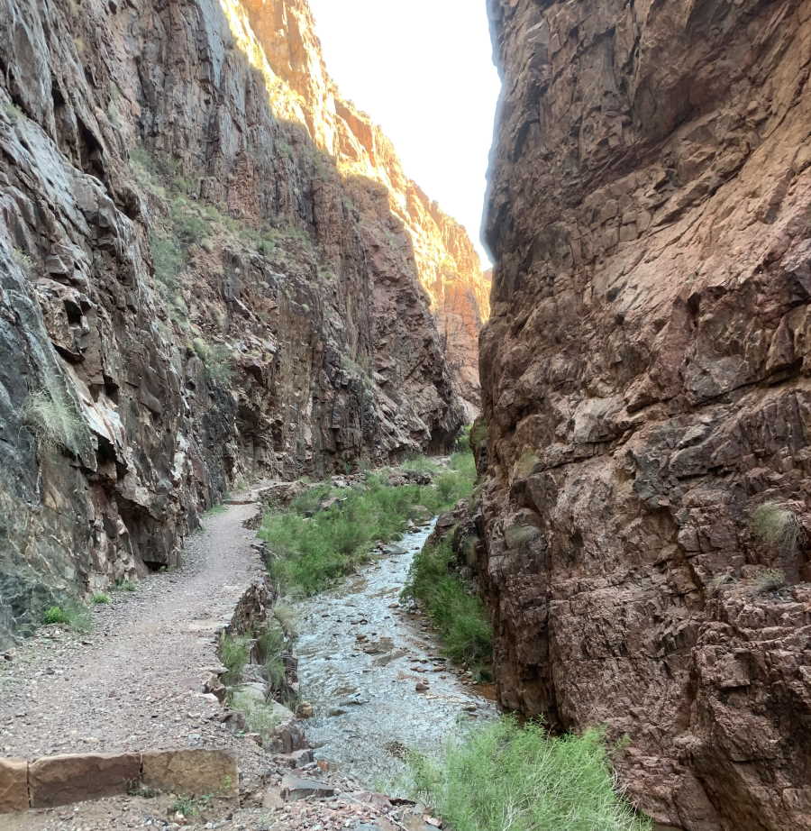
We took the warnings seriously but rationalized that we would be okay. We knew that the 4-mile / 6.5 kilometer section of trail known as “the Box” was where the heat would be the biggest threat but were confident that our 3:30am start would allow us to be safely out of it by 9am before the sun rose too high in the sky. Similarly, we felt that our transit back through the Box on our return to the South Rim would be well-timed to avoid the worst of the heat. Per our plan we would re-enter it around sunset at 7pm. The Box is notoriously hot even on relatively mild days because there the Canyon narrows dramatically and the walls act as giant heat reflectors. It warms like an oven under the Arizona sun. While there are no trail signs defining its limits, it is generally agreed that the Box starts a short distance up-trail from Phantom Ranch and ends at a bridge over Bright Angel Creek about 2½ miles / 4 kilometers down-trail from Cottonwood Camp.
Starting Out: Kachina Lodge to Indian Garden
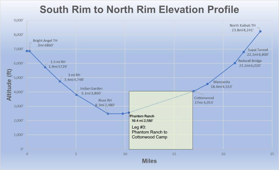
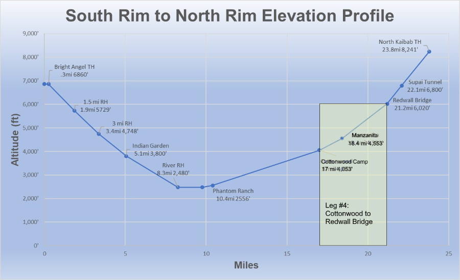
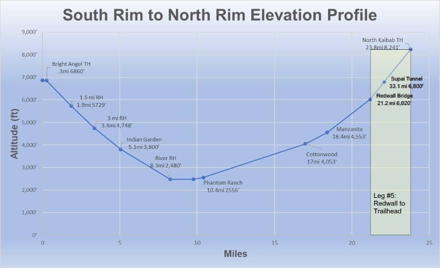
Leg Distance / Time: 5.1 miles (8.1 KM) / 2:00:24
Cumulative Distance / Time: 5.1 miles (8.1 KM) / 2:00:24
Leg Elevation Change: -948’ (-289m)
Distance Remaining to North Rim: 18.7 miles (30.2 KM)
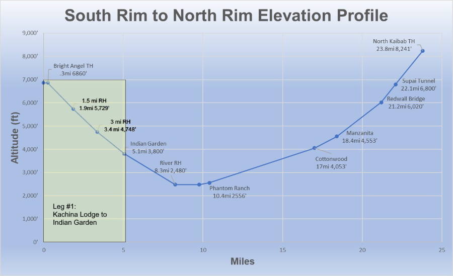
It felt slightly crazy to be starting out at 3:30am scant hours after first arriving at the Park. Despite getting very little sleep, I was excited to be underway and the night was pleasantly cool. I was brimming with optimism. Even though we budgeted no time for acclimatization, the South Rim’s 6,460’ / 2,091m altitude posed no problem at all because the first few miles of the trek are downhill every step of the way. Not surprisingly, we were practically the only people on the trail all the way down to Indian Garden. The only other person we met along the way was a Rim-River-Rim hiker who had started out from the South Kaibab Trailhead at 8:30pm the night before and was closing in on the finishing line. He explained that he had always wanted to do the hike at night aided only by the light of the full moon. After 7½ hours of hiking, he was tired but happy to be almost near the end when we met him at 1½ Mile Resthouse.
By the time we reached Indian Garden for our first scheduled rest stop we were 2 hours into the hike and pre-dawn light was starting to flood the canyon. One of the pleasantly sensible things about Arizona is that Daylight Savings Time is not practiced there and it is at GMT -7 all year round. Because of this, we began seeing the first hints of dawn well before 5am. At Indian Garden we were able to turn our headlamps off and stash them for the duration. I was grateful to do so because I dislike hiking in the dark. A less welcome harbinger of things to come was that the air was warming rapidly and the light fleece jackets that felt so cozy at the start were now working against us. We stashed them for the duration as well.
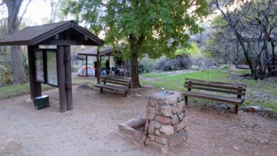
Indian Garden is a wonderful place abounding in shady cottonwood trees, comfortable campsites, rest rooms and sparkling fresh piped-in water. It pleased me to think that we would see the source of all that water at Roaring Springs in just a few hours’ time.
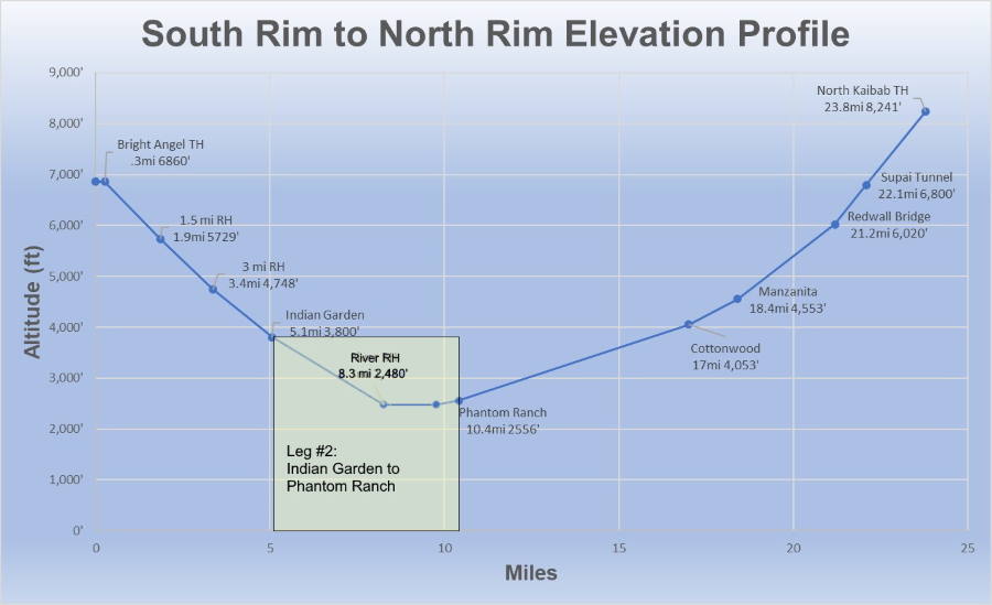
The Descent Continues: Indian Garden to Phantom Ranch
Leg Distance / Time: 5.3 miles (8.1 KM) / 1:58:04
Cumulative Distance / Time: 10.4 miles (16.7 KM) / 4:10:36
Leg Elevation Change: -1,244’ (-379m)
Distance Remaining to North Rim: 13.4 miles (21.6 KM)
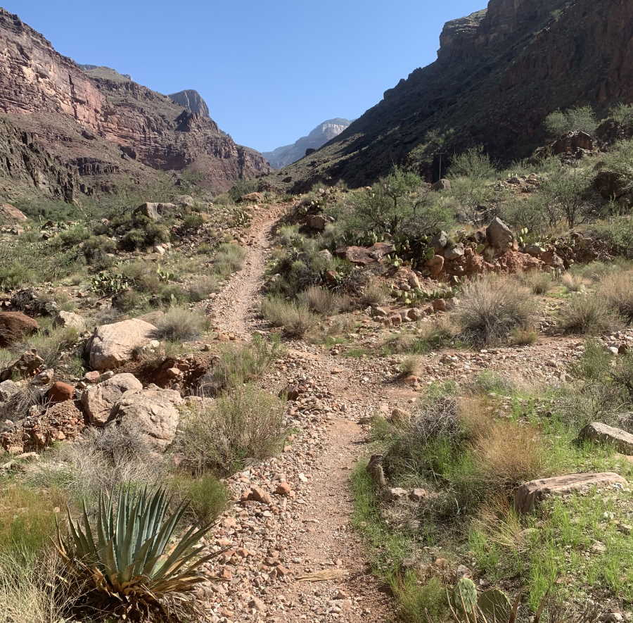
The brightening skies along the way to the Colorado River revealed that the Bright Angel Trail was in rough shape. It was painfully apparent that the regular maintenance that in past years earned it the title of “Superhighway of the Grand Canyon” had been deferred for a long time. Now it was filled with ruts, loose stones and areas of collapse. Pre-trip I had assumed that Germaine and I would be able to travel at a 20 minute per mile pace from the trailhead to Phantom Ranch. Our actual pace was much slower and I worried that this might hurt our chances of finishing the R2R2R within 24-hours.
Trail conditions made our pace slower than expected.
On the good side of the balance sheet, I realized that in six prior trips to the Grand Canyon I had never before actually gone down the Bright Angel Trail . On all other trips I had come up it, most of the time battling to ascend it as quickly as possible and largely oblivious to its scenic beauty. It was genuinely thrilling to see it from a whole new angle and without self-imposed blinders. For example, I never knew how wonderfully designed the “Devil’s Corkscrew” section of the trail was until I saw it laid out at my feet.
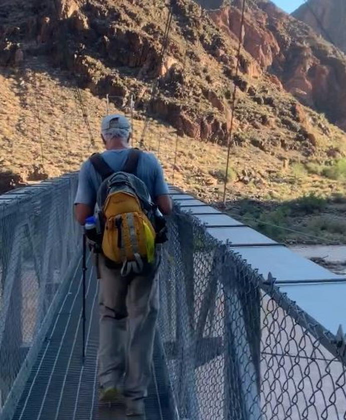
After crossing the Colorado River via the Silver Bridge and passing a few quiet tents at Bright Angel Campground we pulled into Phantom Ranch at about 7:40am, 2 hours after leaving Indian Garden. More than 4 hours on the trail left me feeling a bit tired but not abnormally so. Germaine, of course, was as fresh as a daisy! We tanked up on water, sandwiches and snacks while sitting in a shady oasis near the up-trail edge of the Ranch. We knew that the easy portion of the trip was finished and that well over a vertical mile of climbing (5,716’ / 1756m) awaited before we could tag the North Rim. Both the Bright Angel Trail and the River Trail were now behind us and the North Kaibab Trail lay ahead. Onward and upward!
The Climb Begins: Phantom Ranch to Cottonwood Camp
Leg Distance / Time: 6.6 miles (10.6 KM) / 2:29:30
Cumulative Distance / Time: 17.0 miles (27.4 KM) / 7:00:31
Elevation Change: 1,497’ (456m)
Distance Remaining to North Rim: 6.8 miles (10.9 KM)
We had programmed the 6.6 mile / 10.6 kilometer slog up to Cottonwood Camp as the longest leg of the trip and were determined to make it in one push. There is no piped in water on this section of the North Kaibab Trail and we were careful to make sure that our water bottles were full when we left Phantom Ranch. While plenty of water is available all along the way from Bright Angel Creek, there is no reason to take it and risk being infected with giardia or cryptosporidium.
As beautiful as it is, there is always a bit of dread connected with entering the Box in Summer!
We entered the Box at a little after 8am and were pleased with our timing. It was hot but not oppressively so. The sun was still low in the sky and we were in shade almost the whole way. To keep track of our progress we counted bridges—when you get to bridge number 5, you are out of the Box and on the high road to Cottonwood. Our 4 mile / 6.5 kilometer trek through the Box went by quickly because the ascent is very gradual. All told, you only gain about 700′ / 213m on this section of the route.
Unfortunately, the shady precincts of the Box were replaced by unrelieved sunlight in the Canyon’s broad central valley. The temperature soared and we were bogged down by the same kind of sketchy trail conditions that we saw on the Bright Angel Trail. It was obvious that deferred maintenance was an issue on the North Kaibab Trail as well. One section of trail was so hemmed in by tall weeds that I wished I had brought a machete along. The upshot was that after whizzing through the Box in an hour and fifteen minutes it took us an equal amount of time to make the final two or three miles to Cottonwood. I was more than a little happy to finally get there.
Cottonwood Camp has nothing like the charm or spaciousness of Indian Garden. It is a hardscrabble little place where weary travelers can find a bit of shade, plenty of piped-in water and not much else. Now, 7 hours and 17 miles / 27.4 kilometers into the hike, I sat down at a tree-shaded picnic table and took stock. The returns from my self-audit were not good. I was already very tired and we had not even begun the most difficult part of the trek. Fully 6.8 miles / 10.9 kilometers of trail and a daunting 4,188’ / 1,277m of climbing remained before we topped out at the North Rim. While I was sure that I would be able to drag myself to the top, I knew with certainty that I would not be in any shape to then turn around and make the return to the South Rim. My pessimism was reinforced when we talked with a couple of hikers (the first we had seen since Phantom Ranch) who had come down from the North Rim and arrived at Cottonwood a little before ourselves. They reported difficult trail conditions and said that it had taken them 4 tough hours to do the distance.
There are times while hiking when distances you dismiss as trivial at home take on a whole new dimension. This was one of them. I weighed the possibility that it would take me upwards of 5 hours to do those miserable few miles. Never in my wildest imaginings did I ever think that my pace could drop below 30 minutes per mile but now 30 minutes per mile seemed like an unreachably optimistic goal. One-step-at-a-time became my mantra as we saddled up for the push to Redwall Bridge. Germaine, of course, was still brimming with energy and took my dimming prospects in stride. She would help get me to the top no matter what.
Tough Going: Cottonwood Camp to Redwall Bridge
Leg Distance / Time: 4.2 miles (6.8 KM) / 2:05:19
Cumulative Distance / Time: 21.2 miles (27.4 KM) / 9:05:50
Elevation Change: 1,967’ (600m)
Distance Remaining to North Rim: 2.6 miles (4.2 KM)
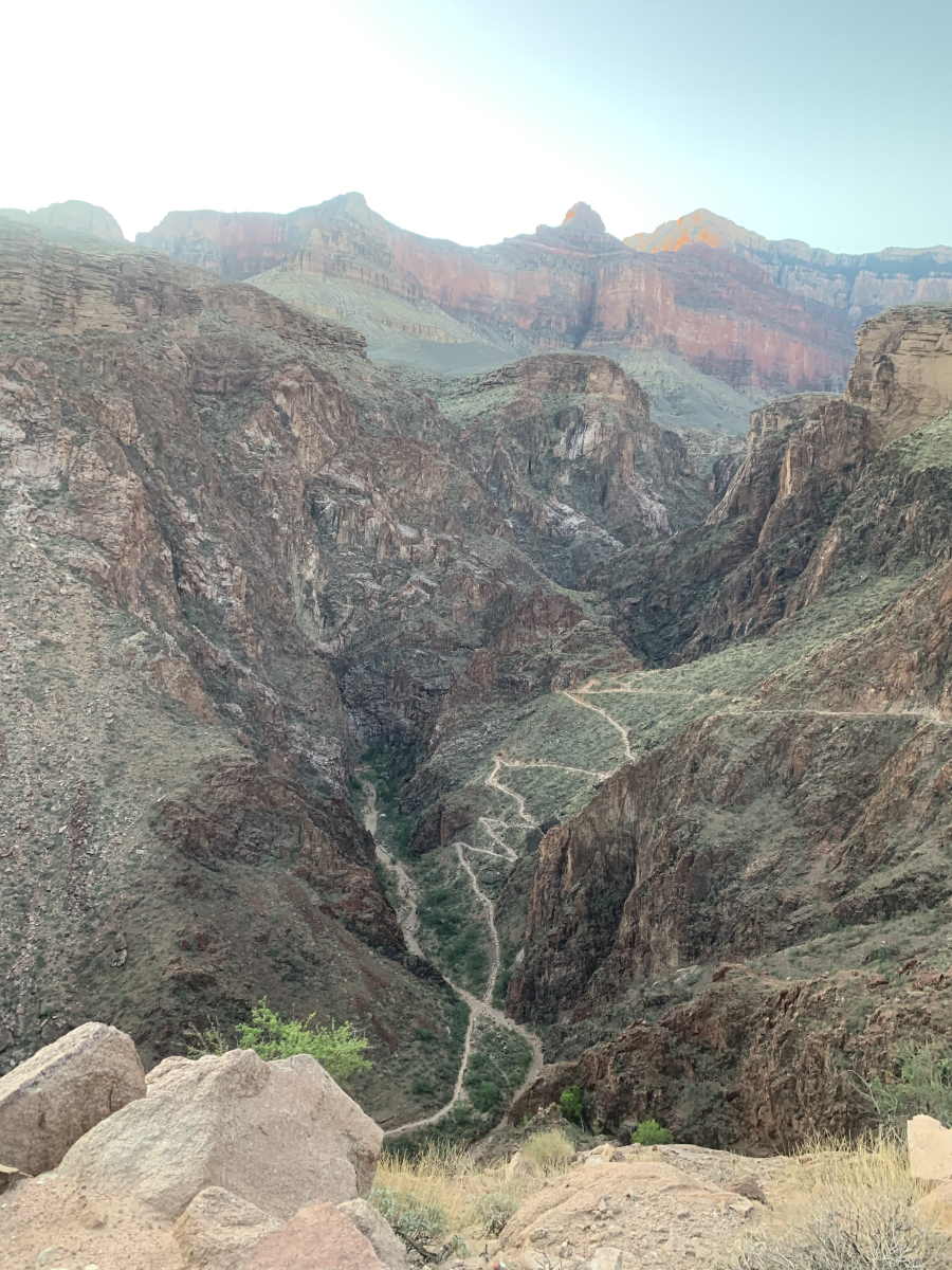
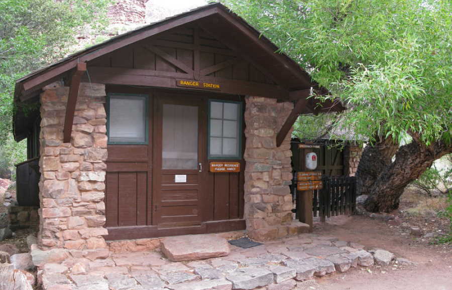
There are lots of enjoyable sights on the way to Redwall Bridge and they help you keep track of your slow upward progress. The Manzanita Rest Area and Ranger Residence come in quick succession about 1.4 miles / 2.3 kilometers above Cottonwood and you get a great view of Roaring Springs across the canyon a half mile after that. It is cheering to see these landmarks come and go. Somewhat less encouraging was the fact that by this point in the hike our GPSs were registering mileage that differed greatly from reality. We had three of the gadgets between us and the trip odometers on all of them had us 1½ to 2½ miles beyond where we knew we actually were. This was an unwelcome distraction.
The scenery below Redwall Bridge helps take your mind off how hard the hiking really is!
GPS coverage in the Grand Canyon has always been a problem. GPS receivers need an unobstructed view of the sky to work correctly and cannot triangulate your position accurately unless locked-in on an array of widely dispersed satellites. The steep walls of the canyon sometimes block reception entirely and often limit the receiver’s line-of-sight to the small cluster of satellites directly overhead. With GPS trip odometers programmed to record a track point every second it is inevitable that many will be off the mark. In consequence, a GPS’s trip odometer might render a 60-second 100-yard walk in a perfectly straight line as a staccato zip-zag of 110 yards with 60 distinct turns. Oddly enough, the exact opposite happens when you save your track at the end of the hike. Then it is common for the GPS software to “summarize” the hike by condensing it to a series of waypoints a fixed distance or time interval apart. My Garmin GPS typically summarizes by saving a track point every one-hundredth of a mile (52.6′ / 16m) and recalculating distance based on that. As a result, all the actual zigs and zags that the trail takes between each hundredth-mile interval are lost and the GPS track distance is always shorter than the real distance.
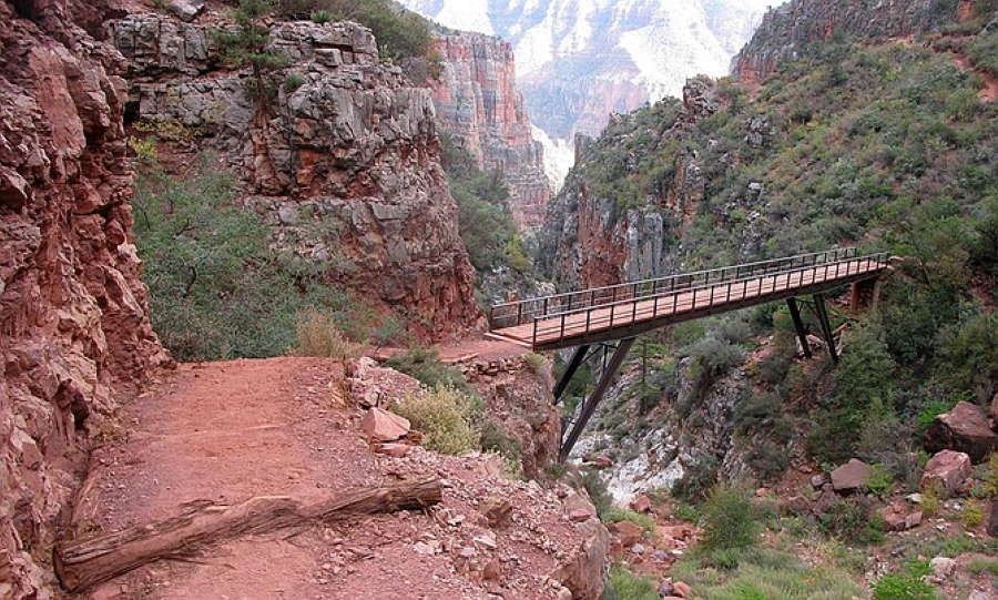
After we passed Roaring Springs, the slog up to Redwall Bridge was brutal. The canyon folds in on itself and the view ahead is limited to the dusty wall that defines the edge of the next switchback. The track was steep and cluttered with rubble. To me, it seemed absolutely endless. It seemed bitterly ironic that the wonderful benefit of cooler temperatures that our ascent brought us was thoroughly negated by the thinning air. Our cramped schedule had allowed no time for acclimatization and even Germaine had to acknowledge the disadvantage. By the time we finally pulled up to Redwall Bridge we were coping with 20% less oxygen than we are used to at home.
The Final Push: Redwall Bridge to Supai Tunnel to North Kaibab Trailhead
Leg Distance / Time: 2.6 miles (4.2 KM) / 2:22:56
Cumulative Distance / Time: 23.8 miles (38.3 KM) / 12:18:17
Elevation Change: 2,121’ (677m)
Distance Remaining to North Rim: -0-
After a sorely needed 20-minute break at Redwall Bridge we began the steep ascent to the Supai Tunnel at 1:25pm. When I hiked this section of trail in the opposite direction seven years ago, I remember being hugely impressed with how artfully built it was and how natural it felt to lose 780’ / 238m of altitude in the space of less than a mile. Now I knew that no amount of trail-making artistry was going to make going back up that hill anything less than a monster of a challenge.
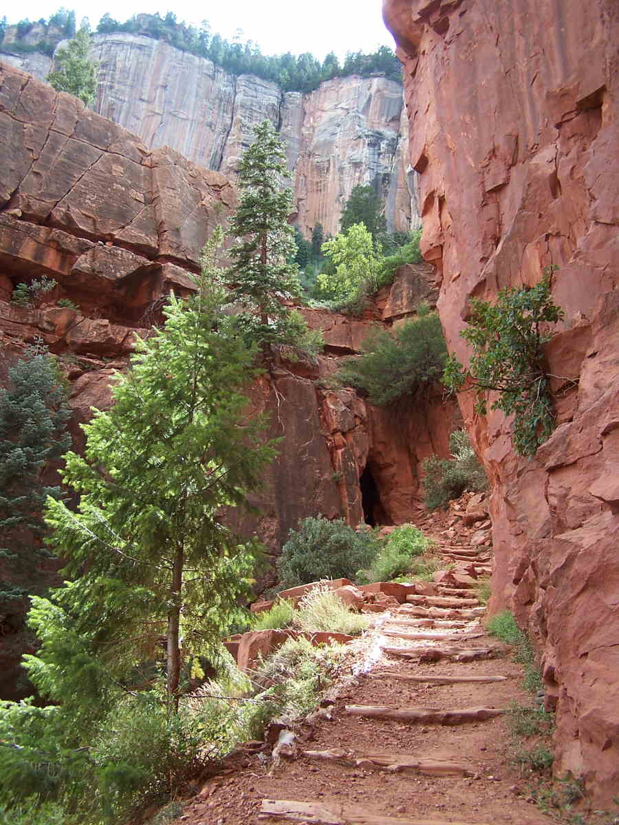
And a challenge it was! I plodded my way up at the exquisitely slow pace of 52 minutes per mile and felt like kissing the tunnel wall when I finally reached it. On the plus side, the rest area just up-trail from the tunnel is shady and blessed with all the piped-in water anyone could want. Also, our timing was fortuitous in that we arrived at about the same time as a mule train of tourists. It was fun to watch this adventurous group exploring the area and marveling at the spectacular view of the canyon as it plunged steeply downhill from the other side of the tunnel. While chatting with the mule riders we were lionized for having hiked all the way from the South Rim. I secretly fantasized about hijacking a mule and letting it carry me to the trailhead. Germaine was probably considering how high a jump she could get one of them over!
Shortly after the trail riders departed, we embarked on the last 1.7 miles / 2.7 kilometers of the trek. It was daunting to know that we still had 1,441’ / 439m of climbing to go but the fact that we were close to the finish line was powerfully encouraging. It was also encouraging to know that we were assured of a place to stay when we finally reached the top. As insurance against possible mishap, I had reserved rooms at the Grand Canyon Lodge– North Rim a couple of months before.
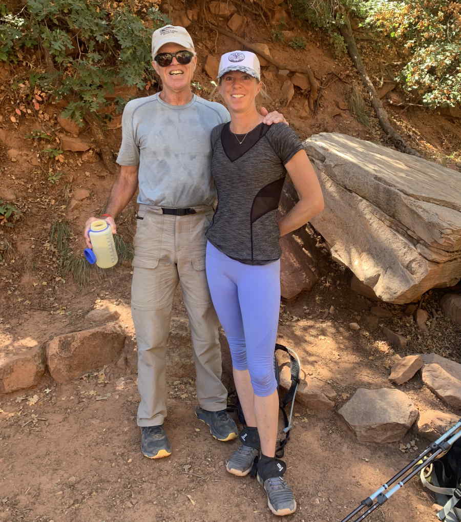
Addled by fatigue as I was, I still found it possible to keep putting one foot in front of the other and was pleased by the fact that the final distance to the North Kaibab Trailhead passes through a shady forest as it switch-backs its way relentlessly upward. We toiled on for an hour and then took our final rest stop of the day. At this point, I had lost any idea of how far we had gone since the Supai Tunnel or what distance was left. As we approached 8,241’ / 2,512m in altitude we were dealing with an oxygen deficiency of 38% versus sea level and I felt it keenly. However, less than fifteen minutes after the break we finally made it to the top. Seeing the Trailhead as we emerged from the woods was one of the most unforgettably happy moments of my life. It was 3:48pm and it had taken us 12 hours and 18 minutes to get there. I could not have done it without Germaine’s steady enthusiasm and support.
We did it!
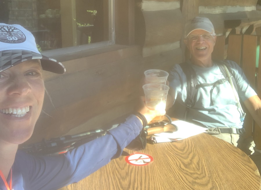
The rest of the trip unfolded smoothly. At the trailhead a family in a motorhome offered to give us a lift to the Grand Canyon Lodge a couple of miles away and we were soon enjoying a life of leisure at two of the “frontier cabins” at the Lodge. We decided to forego hiking back to the South Rim the next morning, opting to take the 7am Trans-Canyon Shuttle instead. While some part of me yearned to complete the double traverse, doing it in two days instead of one did not appeal. Maybe next time!
Postscript
Traversing the Grand Canyon in either direction is very hard work. But, doing the South Rim to North Rim Traverse is truly doing it the hard way. On paper the extra 1,377’ / 420m of elevation gain does not seem like much. In person it grows exponentially. In addition, when heading North after you hit Bright Angel Campground you have 14 miles / 23 kilometers of uninterrupted uphill travel before you. This is much harder to cope with than the 8 miles / 13 kilometers of steady uphill you face when going in the other direction from River Resthouse to the South Rim. My advice to first-timers? Get at least one North to South traverse in before even thinking about hiking South to North!
Any traverse of the Grand Canyon requires preparation and planning. In planning our R2R2R trip I made two fundamentally bad choices that wrecked our chances of completing the double traverse. First, it was a huge mistake to schedule the trip for August. Our chances for avoiding debilitating heat would have been much better if we had done it in October. Second, I should have known that coming up from sea level to the North Rim’s airy heights without allowing at least one full night’s acclimatization time invited disaster. An extra night on the South Rim would have helped materially.
In all my previous trips to the Grand Canyon I had always been the strong hiker who regarded with sympathy the demoralized faces of those struggling upward as I quickly passed by. It was a new and chastening experience on this trip to join the ranks of the strugglers and see my daughter as a seemingly tireless juggernaut. My hope is that this new perspective will help me be a better hiker in the future. Who knows? Maybe the next time I try the R2R2R I’ll be successful!