Epic on Mt Kosciuszko
There is no question that Mt Kosciuszko is the easiest of the Seven Summits, that collection of the highest peaks on each of the seven continents that has been the grail of mountaineers from the dawn of the modern era of guided climbing in the mid-1980s. The graphic below says it all.
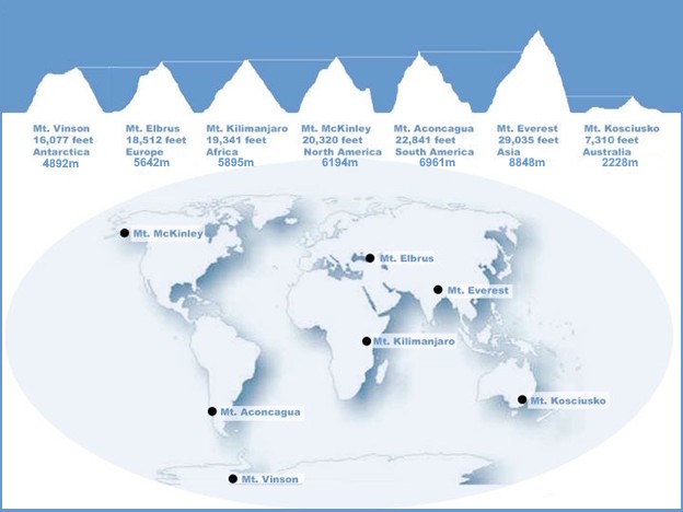
Not only is Kosciuszko the shortest of the Seven Summits with its peak being more than 10,000 feet / 3,048 meters lower than Base Camp on Mt Everest, but the trail most of the way to the top is a sturdy raised metal walkway that eliminates any chance of stubbing your toe on an unfriendly rock or muddying your boots while crossing a stream. The thoroughly civilized nature of the Mt Kosciuszko Summit Walk attracts a crowd. Of the 2.5 million annual visitors to Kosciuszko National Park, it is estimated that 100,000 hike to the summit every year. It is likely most of these have never even heard of the Seven Summits.
Mt Kosciuszko’s summit is fully 10,000 feet lower than Base Camp on Mt Everest
Getting to Mt Kosciuszko
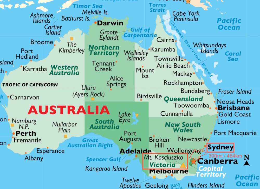
When travelling from the United States the most logical route is to fly to Sydney, Australia and then drive to the village of Thredbo in New South Wales. Thredbo is entirely within the borders of Kosciuszko National Park and is a 6-hour, 300-mile / 484-kilometer drive from Sydney.
Naturally, the most daunting part of the trip is the air journey. For me, it involved a 17 hour 35-minute nonstop flight from Houston covering the extraordinary distance of 8,596 miles / 13,865 kilometers. This trip, aboard a 787-9 aircraft, ranks as the tenth longest nonstop flight currently being flown in the world today.
Controversy?
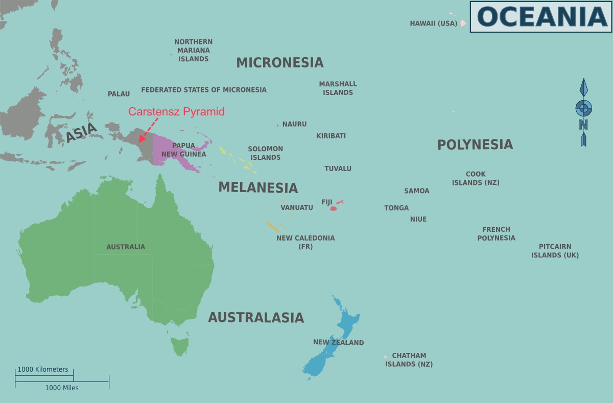
There is some disagreement among mountaineers as to whether Mt Kosciuszko (“Kozzie” as the Australians call it) is a member of the Seven Summits at all. Some argue that Australia is not a continent itself but rather is a part of that South Pacific group of lands that make up the “Oceania” continent. Based on this definition, Kozzie is out of the running because Puncak Jaya (more commonly known as Carstensz Pyramid) in West Guinea is 16,024 feet / 4,884 meters tall.
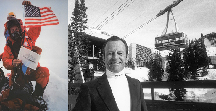
Seven Summits Lists: “Bass List” versus “Messner List”
The world’s Greatest-Of-All-Time mountaineer, Reinhold Messner, is an advocate of the Oceania definition and the Seven Summits list that includes Cartensz Pyramid has come to be called the “Messner List.”
On the other hand, it makes sense to trace the Seven Summits list back to its origins. Based on generally held geographical concepts Australia is a “continent” and Oceania merely a region containing a continent. Dick Bass staunchly advocated this commonsense approach, and his Seven Summits list includes Mt Kosciuszko. His list is called the “Bass List.” Why do we care about what Dick Bass thinks? Easy! He is the guy who first climbed all of the Seven Summits and made doing it a “thing.” More importantly, Bass and his climbing partner, Frank Wells, entertainingly chronicled their quest to climb these peaks and produced a bestselling 1986 book on the subject, the Seven Summits. The book served as an inspiration for countless would-be mountaineers because it demonstrated that virtually any mountain on Earth could be climbed by anyone with sufficient determination to try. In a very real sense Bass’s achievement and the book gave birth to the modern era of guided climbing. If a 55-year-old amateur could reach the summit of Mt Everest, why not me? This was the question thousands of readers asked themselves and legions of professional mountaineers came forward to provide the logistics and safety net needed to let them find out. In all walks of life having a concrete goal encourages action. Climbing the Seven Summits is a goal that has captured the public’s imagination more than anything else in the world of mountaineering.
For better or worse and with due deference to GOAT Messner, I am sticking with Kozzie as the legitimate Seven Summits member. I am a big fan of Dick Bass and have always felt that Carstensz Pyramid shouldered its way into the Seven Summits list only at the insistence of the mountain guiding companies whose business interests prospered by its addition!
Route to Kosciuszko Summit
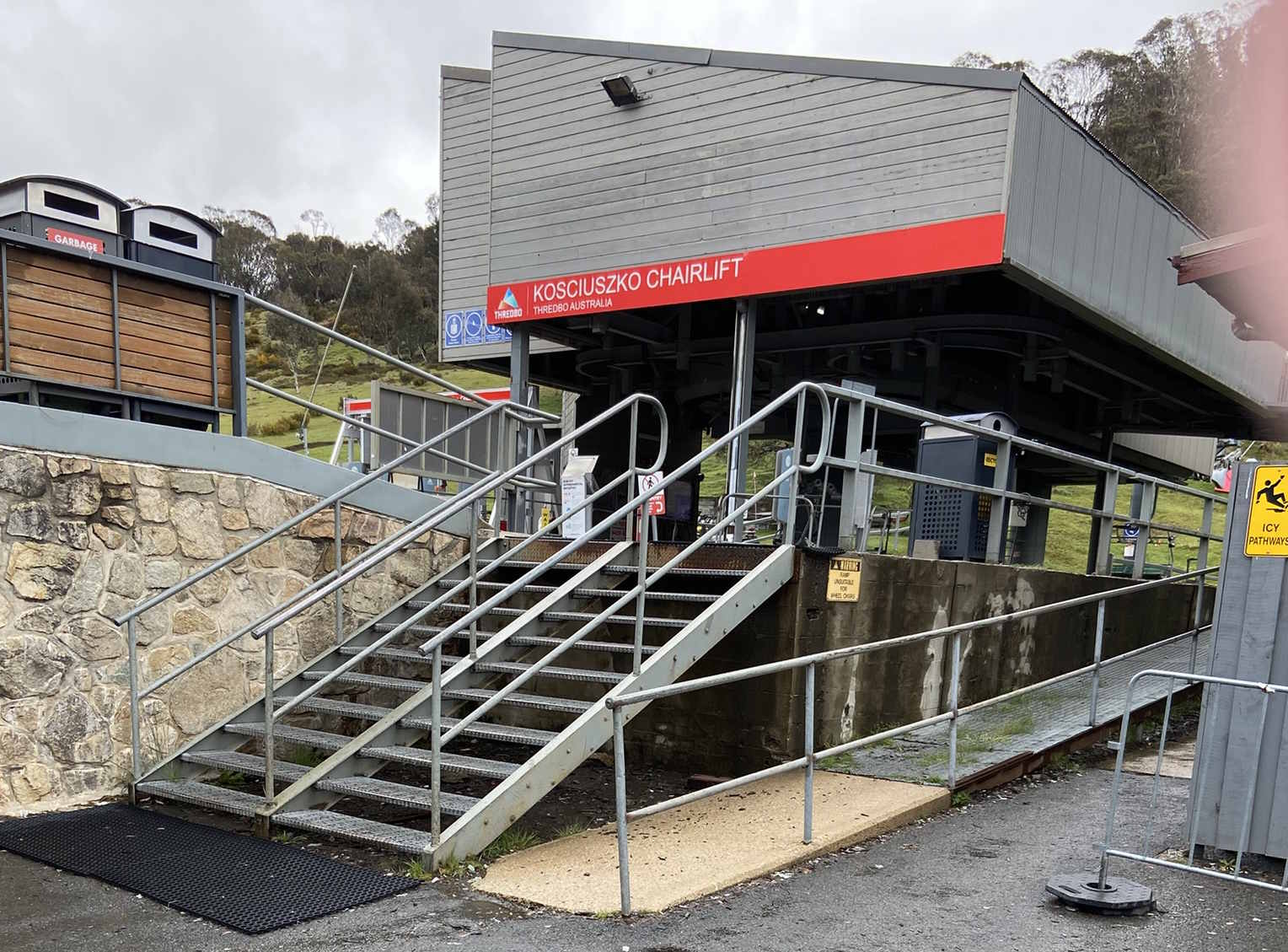
From the base of the mountain at the Thredbo Ski Resort, the start of the official “Mt Kosciuszko Summit Walk” is a 10-minute chairlift ride away. The Kosciuszko Express Chairlift operates year-round. If it happens to be closed for maintenance, the adjacent Snowgums Lift will drop you off a 5-minute walk away from the start. For those preferring to hike to the start, a trail called the Merritts Nature Track is available. It is a 2.4-mile / 4-kilometer hike involving 1,820’ / 555m of vertical gain. By all reports, the hike is a little-used option. During my visit on November 17, 2025 the Merritts Nature Track was closed for reasons unknown.

Once you are at the official start at the chairlift terminus, the summit is 3.8-miles / 6.2-kilometers away. The elevation gain on the route is a modest 980’ / 299m. The ascent is so gradual that wheelchair athletes regularly make it to the top. Here is an accurate representation of the slope to the summit:

Anyone who can walk up this hill can become a Kozzie summiteer!
Mt Kosciuszko is by far the most accessible of the Seven Summits
There are only two clearly established waypoints on the way to the top. After leaving the chairlift terminus (6,330’ / 1929m) you will pass over a short bridge onto a metal-grate trail and hike 1.2-miles / 2-kilometers to Kosciuszko Lookout. This is the first marked waypoint. Along the way you will gain 438’ / 134m in altitude. Off to the right of the trail there is an attractive viewing platform. The area is clearly identified with a sign. The second waypoint before the summit is Rawson Pass. It comes 1.6-miles / 2.6-kilometers and 200’ / 61m above Kosciuszko Lookout. It is clearly marked and boasts the highest altitude toilet in all of Australia.
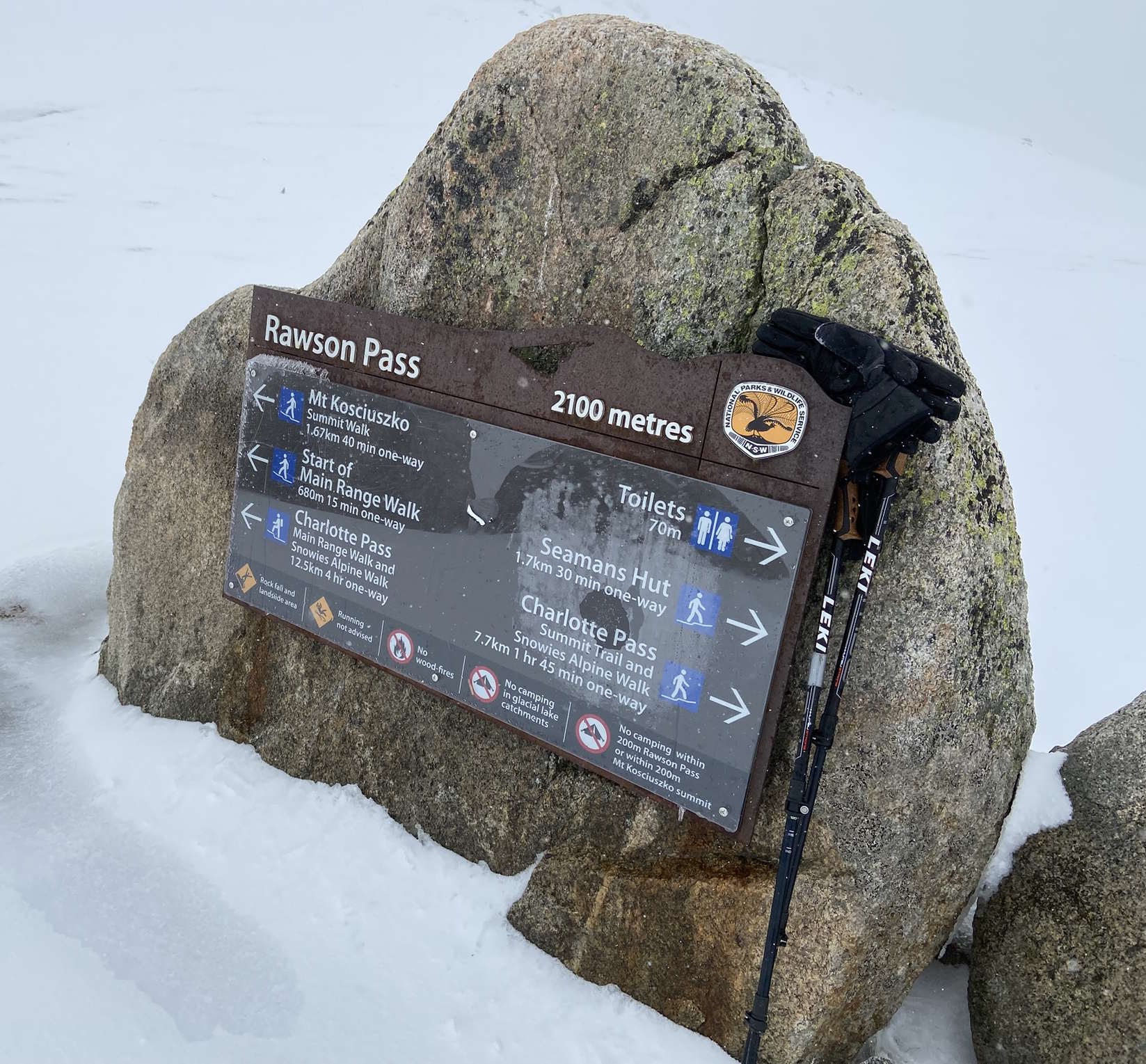
At Rawson Pass the raised metal-grate trail ends and is replaced by a simple crushed gravel track. On it you will travel 1-mile / 1.7-kilometers further before reaching the summit at 7,310’ / 2,228m. On this final leg of the journey, you will gain an additional 342’ / 104m in altitude. According to the official route guide, you should allow 4-6 hours to do the 7.6-mile / 12.6-kilometer round trip.
Bad Weather on Kozzie—My Hike to the Top
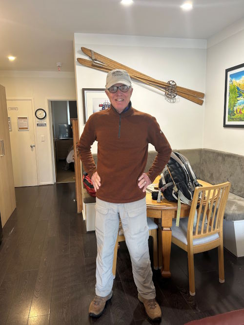
After completing the 6-hour drive from Sydney, I checked into a comfortable Airbnb condominium in Thredbo Village, a 10-minute walk from the ski area. Thredbo is a beautiful location with the Village tucked into a slender valley with imposing mountains on either side. After arriving, I scouted the location of the chairlift and beginning of Merritts Nature Track. I was disappointed to find the Track closed to visitors. My original intention was to forego the chairlift and hike to the start of the Mt Kosciuszko Summit Walk. This small disappointment aside, it was wonderful to be in the mountains again and I eagerly looked forward to doing the Summit Walk the next day.
Unfortunately, the next day dawned blustery and wet. The early morning view from the condo’s balcony promised a wet and miserable trudge up the mountain.
Since I was resigned to using the chairlift and it did not begin to operate until 9am, I was able to forego the customary (for mountain adventures) pre-dawn start and sleep late.
Upon arriving at the Kosciuszko Express Chairlift, the operator warned me that conditions on the trail to the summit were awful and that the rain would turn to snow before I was halfway up the lift. He was absolutely correct. However, once at the top of the lift I was delighted to find the metal Summit Walk trail well-marked and reassuringly robust. My only concerns were that I seemed to be the only person doing the hike today and that snow had accumulated to the point that for long stretches the metal track disappeared completely. I was relieved when the fog parted long enough for me to glimpse two other hikers ahead and on passing them a group of 25 teenagers being led up the mountain by a pair of guides. I passed this very slow-moving group just before reaching Kosciuszko Lookout.
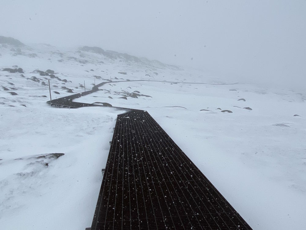
After Kosciuszko Lookout the trail slopes downhill for some distance before resuming its upward march. In this little decline the fog thickened to the point where it was impossible to see more than a few feet ahead. With the trail completely snow-covered and visibility terrible I was very grateful that 6’ / 2m tall wooden posts periodically marked the boundary of the trail. It was fascinating to forge forward completely blind into the fog and heavy snow and then catch sight of the next post along the way. There is no doubt that these posts have relieved the anxiety of hundreds of fog-plagued travelers over the years. They certainly did mine!
Trail boundary posts along the track were hugely important on this foggy day
Just before reaching Rawson Pass I met the only descending group of hikers I was to meet all day. This group of four told me that they had reached the summit but that conditions were “impossible.” Not long after I found that their assessment was 100% accurate. The reason is that after Rawson Pass, the metal grate trail and its helpfully-spaced guide posts is replaced by a simple gravel track. On this day, the gravel track was completely covered by deep snow, visibility was nil and the only indication of where the summit might be was the fast-disappearing tracks of the foursome I had met a half-hour before.
I pushed ahead, groping for any sign of tracks or trail for a few hundred yards before facing the facts. No trace of the earlier party remained and I risked becoming hopelessly lost if I continued. I cursed the fact that I had not brought my GPS with me and had neither a waypoint for the summit nor Rawson Pass to navigate by. While I was sure that I could eventually find the summit by continuing to climb upwards, once there every direction was “down” and the risk of not finding my way back to Rawson Pass was unacceptably high. I turned around, bemused by the fact that I had traveled halfway across the world to fail to complete a simple day-hike.
However, luck was with me!
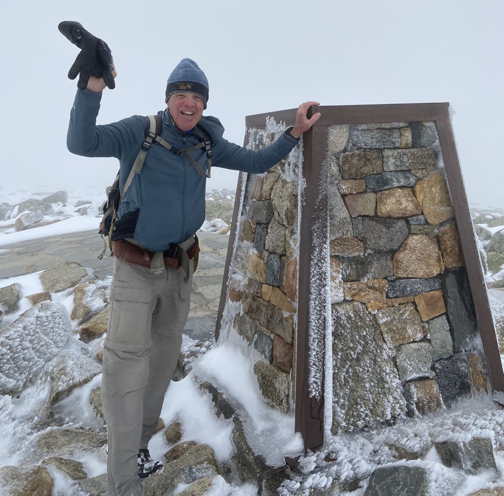
Five minutes after starting back down, a gap in the storm revealed a cross-country skier coming uphill in my tracks. Shouting over the raging wind, I learned that he (Monte) was headed towards the summit and was confident of its direction and the way back down. He said he had been to the top many times before and was happy to have me as company along the way. I followed in his tracks and 20 minutes after meeting, he stopped and pointed his ski pole towards a rocky outcropping ahead. Behind it was the summit plateau and the stone summit marker. What a thrill!

We took the customary summit photos but did not linger long at the top. There would be no picnicking on the summit of Mt Kosciuszko this day. The snow continued to drive horizontally in the gale and our tracks were quickly being erased. Nonetheless, within a half-hour we were close to Rawson Pass and met the guided party of teenagers still on their way up. I was astonished that the guides had not turned them around earlier in the day. Good for them! There is no doubt that the memory of having conquered Kozzie in a whiteout will be cherished by those teens for the rest of their lives.
Shortly after meeting the guided group, Monte and I parted company, he to enjoy a fun downhill ski run and me to retrace my steps back to the ski lift. Thanks, Monte! I couldn’t have done it without you!
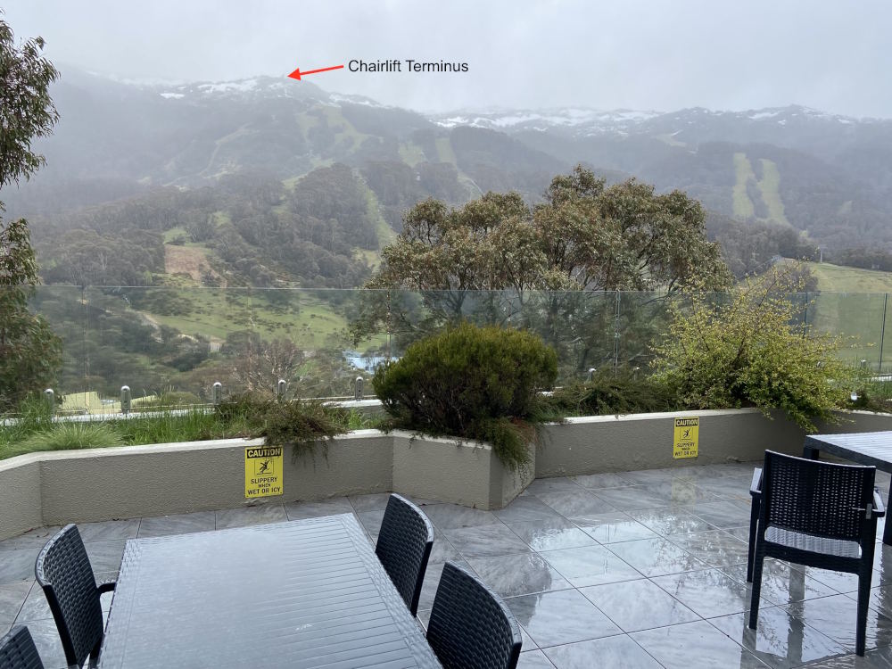
Conditions changed from Winter to Spring during a 10-minute chairlift ride down the mountain
The walk down was uneventful. I met the two hikers who I had passed on the way up earlier in the day and they sadly related that they had turned back at Rawson Pass. The only other person I encountered was a man on the way up who said that he had already abandoned hope of getting any further than Kosciuszko Lookout. In any event, 3 hours and 40 minutes after setting off on the hike I was back at the Summit Walk starting point and on my way down via the chairlift. It was great to be able to sit after that much time on my feet and enjoy the transition from full-on Winter conditions to a wet Spring as the chairlift rapidly descended to the base. On the way down, I reflected on the astonishing difference altitude makes to weather conditions. Mt Kosciuszko lies at about 36 degrees South latitude, roughly the same distance South of the Equator as Monterey, California is North of it. In the Southern Hemisphere, the seasons are flipped from what we Northern Hemisphere residents experience so November in Australia corresponds to May in the United States. On this day, I vividly saw that when you add 7,310’ / 2,228m in altitude to the mix, the harbingers of Spring can instantly be erased by a raging snowstorm.
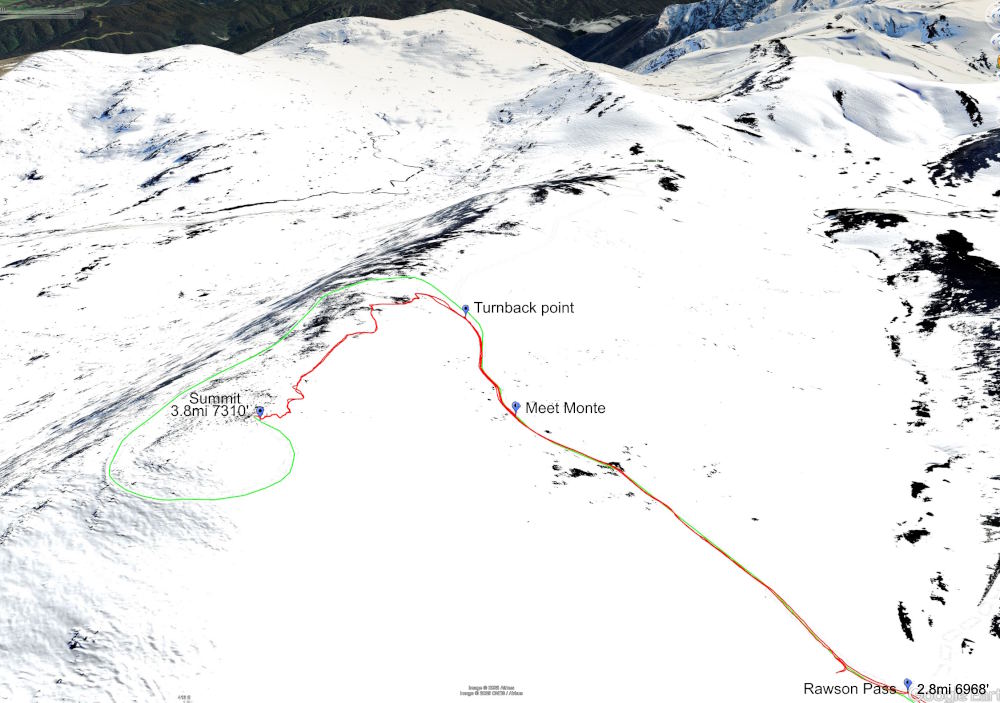
I recorded a track of the hike on my Suunto watch and imported it into GoogleEarth to see how far off the official Summit Walk path Monte and I had gone. It shows (red track) that we took a rather direct route to the top.
A Great Mountain Experience
Mountains often provide climbers with surprises. My expected Springtime stroll turned into a wonderfully rich Winter hiking experience. I would not have had it any other way!